


- Home / Sensors / Solar Spectral Irradiance / Direct Solar Spectral Irradiance
Direct Solar Spectral Irradiance
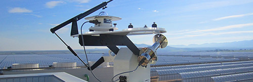
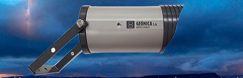
The GEO-SolarSIM-D2 is a revolutionary new approach to solar and atmospheric measurement. It uses simple robust hardware and innovative software.
The GEO-SolarSIM-D2 is a Solar Spectroradiometer, a Sun Photometer and a Pyrheliometer, All-in One. The GEO-SolarSIM-D2 represents a bold new approach to solar and atmospheric measurement. It uses simple, rugged hardware and ground-breaking software to slash the cost of measuring the Direct Solar Spectrum, Aerosol Optical Depth, Water Vapour Content and the Ozone Level, all in one compact, low-power device.
The D2 uses silicon photodiodes, integrated with bandpass interference filters to measure the direct solar spectrum in several narrow wavelength bands.
The GEO-SolarSIM-D2’s proprietary software then uses these measurements to resolve the complete solar spectrum, in addition to major atmospheric variables, such as air mass, Rayleigh scattering, aerosol optical depth, ozone-layer thickness and atmospheric water vapour content.
This smart spectral sensor is designed to provide the scientific community and the Solar Industry with a versatile, low-cost, low-power tool for accurately determining the direct solar spectrum, DNI, and major atmospheric constituents as part of on-site solar resource and atmospheric characterization studies.
So much Data
The D2 is a hugely versatile device that provides the function of a Spectroradiometer, a Pyrheliometer, a Sun Photometer and an Ozone Spectrophotometer, all in one. As a result the unit provides an unparalleled quantity and quality of data over 14,000 data points per time stamp.
Direct Spectral Irradiance
The D2 resolves the direct solar spectral irradiance over the complete spectral range 280 – 4000 nm, with 1nm resolution.
Direct Normal Irradiance
Because the D2 resolves the solar spectrum over the complete spectral range, the integral of the spectrum is used to provide an accurate measurement of the direct normal irradiance (DNI).
Aerosol Optical Depth
The D2 provides aerosol optical depth values for each wavelength over the complete 280 – 4000 nm range.
Ozone content
The D2 resolves atmospheric ozone absorption values for each wavelength over the complete wavelength range, in addition to the total ozone layer thickness.
Precipitable Water Vapour
The D2 resolves atmospheric precipitable water vapour values for each wavelength over the complete wavelength range, in addition to the total column amount.
Automatic Operation and Connectivity
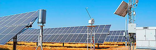
For automatic operation, the GEO-SolarSIM-D2 is mounted indistinctly on the GEONICA’s SunTracker-2000 or 3000 trackers , in such a way to precisely point the Sun continuously. Direct Solar Irradiance measurements at six different wavelengths, plus the temperature and the atmospheric pressure, are then measured and the individual raw data are transferred to our Datalogger METEODATA via a digital serial port.
The Software and Data Visualization
Therefore, the software package must be installed on the computer of the Central Receiving Station for final data processing, database generation and visualization. The GEO-SolarSIM-D2 software features a windowsbased graphical user interface (GUI) that provides user with easy visualization of all of the GEO-SolarSIM-D2’s data streams.
Features include
- Visualisation of instantaneous spectral irradiance.
- Continuously updating daily plots of DNI, AOD, ozone.
- Visualisation of raw optical channel outputs.
- Internal humidity monitor.
- Customised data acquisition rates for different datastreams.
- Internal heater with automatic control by the datalogger.
Main Areas of Application
- Correction of atmospheric components (AOD, Water Vapor and Ozone) from satellite and models used in clear-sky models.
- Decrease the uncertainty in the long-term estimation of Direct Normal Irradiance (DNI).
- Precise identification of clear sky conditions analyzing spectral bands attenuated by clouds. Especially important in areas of high turbidity as the Middle East, India, etc. since in base of pyranometric data and current algorithms it is not possible to identify clear sky conditions.
- In Solar Power Tower plants, characterization of the attenuation of solar radiation in the path from the heliostats to the solar receiver.
- Precise solar radiation predictions using on-site atmospheric components to correct modeled AOD, WV, Ozone and rest of components.
- Selection of best photovoltaic technologies for specific locations based on its spectral response.
- Accurate predictions from sky imagers combined with spectral radiation and radiative transfer model (RTM).
- Modelling and predicting the output of Concentrating Photovoltaic (CPV) accurately through its spectral response.
Connectivity
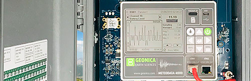
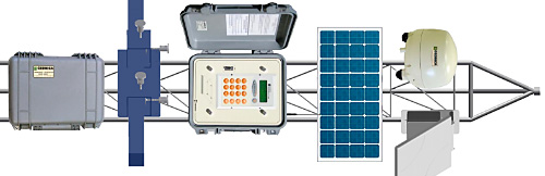
The GEO-SolarSIM-D2 is directly connected to our Datalogger METEODATA via RS485 port as an integral part of our Solar Energy Measurement System (SEMS-2000/3000), described in a separate brochure and illustrated in the picture shown below.
The Mounting Support
With the device is offered a standard, anodized aluminum mounting adaptor, Model SP-D2 suitable for mounting the GEO-SolarSIM-D2 on our trackers Model SunTracker-2000 or 3000 series, which are also part of the SEMS-2000 or 3000 Systems.
OTHER SPECTRUM SENSORS SOLAR RADIATION
DOCUMENTATION
Dataloggers Serie 4000
Dataloggers Serie 4000
Dataloggers Serie 4000